Promoting awareness of the archaeology and history of North Devon

Copyright © 2015 North Devon Archaeological Society
Six Acre Farm, Caffyns -
Six Acre farm, at Caffyns near Lynton, came to the notice of historians in 1913,
when the Rev. Chanter discovered a stone inscribed in Latin dating from the 6th century
AD. At that time, the stone was serving as a gatepost near the farm entrance. It
bears the inscription CAVUDI FILIUS CIVILIS: “(the grave of )Cavudus, son of Civilis”.
It belongs among a class of post-
Discussion with the previous farm owner, has revealed that around 35 years ago, her husband uncovered what appeared to be a shallow, seashell lined grave when ploughing a field. It is known that occasionally the Romans lined their graves with seashells, so this information raised the remote possibility that the site might be Roman in origin
The present owners, are very interested in the farm’s history, and organised a farm walk for a few NDAS members on 6th June this year.
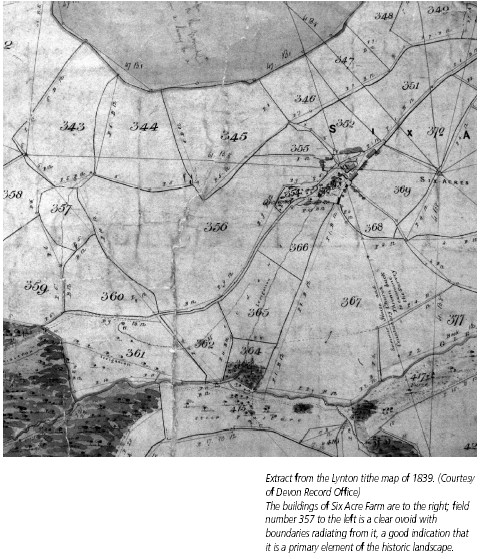
Nothing was visible at the sea shell site, but it lay next to an obvious cornditch (a medieval arrangement for controlling the movement of stock). The cornditch is about 350 metres in length and encloses an ovoid area, which the map reveals to be a primary enclosure with five other field boundaries radiating from it. The cornditch has recently been renovated, interestingly turning up seashells, and pieces of medieval pottery. Inside the enclosure is a platform from the edge of which David Parker removed a little turf and had a scrape with his trowel revealing a large horizontal stone , which could possibly be part of the wall of a building. The possibility of a geophysical survey was discussed which Liz and John enthusiastically welcomed.
Research in the Record Offices has turned up a lot of interesting detail regarding Six Acre and Caffyns. Both of these farms descend from the Domesday manor of Hantona (‘at the high farm’), later known as Caffyns Heanton (the family of Caffyn or Coffin is prominent in the history of North Devon.) Very interestingly, the ovoid enclosure discussed above, number 357 on the 1839 Lynton tithe map (Plate 1), is named in the Lynton tithe award “Henton or North Meadow”. This strongly reinforces the idea that there may be an abandoned medieval settlement here and that it may actually be the Domesday “Hantona”, the name of which has since migrated.
Unusually there is medieval documentation referring to this manor. In the reign of King John, the Manor of Lynton and Countisbury, of which Heanton was a part, was granted to Ford Abbey in Dorset. In 1282, Richard le Pronote of Ford Abbey, unjustly dispossessed the farmer William Coffin of his “commons of pasture in Lynton which pertains to his free tenement in Heanton, namely 500 acres of hill and heathland for every kind of his livestock throughout the year.” When the case was brought to court, the jurors found in favour of William who recovered the rights and received compensation. (Cartulary of Ford Abbey, page 432, Somerset Record Society)
This site is interesting in a number of ways. The inscribed stone quite clearly indicates habitation somewhere nearby in the 6th century, the ovoid enclosure is a primary element in the historic landscape and there is a medieval documentary link to a settlement that may have stood within it. Interestingly the name of the neighbouring farm to the west, Croscombe, also part of the manor of Lynton, conceals the name of a Briton, “Caradoc” who could well have been a descendant of Cavudus. There is much to engage our attention here.
Six Acre Farm, Lynton: Update -
(Newsletter No 12 2006)
In the Autumn 2005 edition of the newsletter we wrote about a developing interest
in Six Acre Farm between Parracombe and Lynton. We reported that an initial visit
had shown us what appeared to be a building platform inside an ovoid enclosure bounded
by a corn-
Since I first visited Six Acre Farm to photograph the corn ditch for an ‘A’ level archaeology project, Elizabeth and John Rodwell have given their permission for NDAS members to undertake surveys.
Before we were able to answer the question: ‘to dig or not to dig and where’?
resistivity and magnetometry surveys were needed, in order to provide data on which to base decisions.
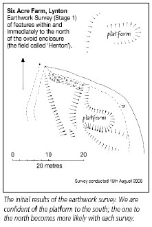
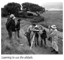
On a wonderfully warm day in June, two teams enjoyed learning how to set out and complete resistivity surveys. The first 20x20 meter square surveyed, included the platform inside the enclosure. Here the survey identified a rectangular feature characterized by high resistance with an area of low resistance inside it. This corresponded well to the visible platform. The survey was extended to take in what appeared to be another platform near the gate into the next field and we went on to survey this field as well. However, the results when processed failed to show anything obviously significant.
While one team was mastering the geophysical survey, the other team took to the hills
to survey field boundaries. This turned up another corn-
In August on a very chilly day, an earthwork survey was conducted by Rob Wilson-
it all look more promising, and when the survey data had been processed, the possibility of a second building outside the enclosure became stronger.
Finally in late October Sean Hawken of XArch (the Community Archaeology Project of Exeter University) carried out a training day to conduct a magnetometry survey. The nature of the ground made this difficult, but the preliminary results do suggest something of interest in the second platform area. There is the suggestion of a hearth within the house platform which could provide charcoal for C14 dating purposes.
When all the surveys have been completed, the Projects Group will discuss the findings and present plans for future work to the Committee. The interest of this site is that it appears to represent an abandoned medieval settlement in an area for which we have corresponding medieval documentary material. The documentation relate to a dispute over grazing rights in a period (13th century) when traditional grazing land was being eaten into by the plough.
It was a period of settlement shift and expansion. Evidence of something more extensive than just a single building together with the field name ‘Henton’ might in fact suggest that this is the original site of Caffyns Heanton which is now on the other side of the valley. Ed.